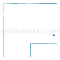
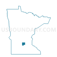
Plato Voting District, McLeod County, Minnesota
About
Outline

Summary
| Unique Area Identifier | 602995 |
| Name | Plato Voting District |
| County | McLeod County |
| State | Minnesota |
| Area (square miles) | 0.35 |
| Land Area (square miles) | 0.35 |
| Water Area (square miles) | 0.00 |
| % of Land Area | 98.63 |
| % of Water Area | 1.37 |
| Latitude of the Internal Point | 44.77235020 |
| Longtitude of the Internal Point | -94.03933700 |
Maps

Graphs
Select a template below for downloading or customizing gragh for Plato Voting District, McLeod County, Minnesota